
Believe it or not, the Capertee Valley in Central West NSW is reported to be the second widest canyon in the World!
That’s a pretty big boast for a pretty small part of Australia, but even if it is not 100% accurate it still delivers when it comes to spectacular views and scrambling up Blackman’s Crown is the perfect way to marvel at those views.
Grab your hat, we’re off on a short scrabble and scramble to the top.

In contrast to the slightly grandiose claims of the neighbouring valley, Blackman’s Crown is only a small dot on a big map. There is no promotion of this walk and no signs indicating where you should park your car, start walking or generally in which rough direction you should head. Thank goodness for the intrepid leaders in our local bushwalking club who knew exactly (well, more or less) were this little adventure should start and finish.
According to the internet (and it couldn’t possibly be wrong??) Blackman’s Crown is named after one of the earliest explorers of the Mudgee region. My initial thought was that it could be referring to the area’s traditional owners, but No. Interestingly, sometimes when you are driving in a northerly direction on the main road below the rocky crown and if the sun is at the right angle, you can clearly see the profile of a man’s face AND he is wearing a broad brimmed Akubra-style hat. Definitely the profile of a white settler and not a Wiradjuri man.

Here are the Nuts and Bolts of this walk:
- Distance: approx. 5.5km return.
- Rating: Medium (my rating).
- Terrain: Some steep climbs and rock scrabbling required to get up to a relatively open and flat area at the top of the ridge. Elevation 810m-1,010m.
- Path: There is no real path other than a rough fire trail which leads you from the car park area to the top of the first ridgeline. From there, make it up as you go along, following animal trails and using rocky outcrops as your guide.
- Mobile Phone Coverage: Patchy at best.
- Water: Take water with you as there are no water sources. This is even more important if you walk in Summer.
- Sun Protection: Wear a hat and sunscreen.
- Snakes: This area would be prime snake country in Summertime. Be careful where you step.
- Bushfires: Be careful with any cigarettes or naked flame. You are walking through the bush with no real escape routes or protected areas, so take care.
- Toilets: The closest toilet facilities are at the large rest area in the centre of Capertee village – about 3km away.
Blackman’s Crown is designated as a Crown Land nature reserve. It has had a bit of a chequered past as a 4WD track, general recreation area and part of it was the community garbage dump. Thankfully those days have passed and the area has been cleaned up somewhat. Apparently, like the surrounding Glen Davis and Newnes districts, shale oil mining/production was carried out in the region from 1905-1932. There are supposed to be old equipment remnants of this activity still around, but I didn’t spot any…just old beer cans. Perhaps also remnants of mining activity?

The lack of signage on this path makes the start of this walk a bit tricky to find. Heading South on the Castlereagh Highway look for an unmarked dirt road about 1.5km after Pearson’s Lookout. Turning right, bump down the dirt road for about 50m, park your car and you will see a faint dirt access road on the right heading into the bush.
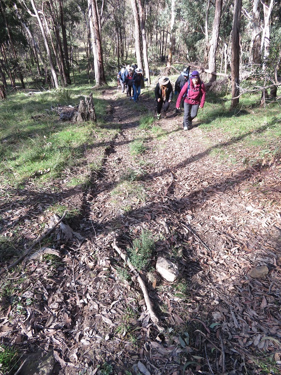
The access road twists and turns through open bushland for about 150m before you hit the bottom of the first ridgeline and the climbing begins. The ol’ heartrate goes from normal to maximum beats-per-minute in about 10 steps and the relaxing bushwalk converts from admiring the scenery to head down and one foot in front of the other.


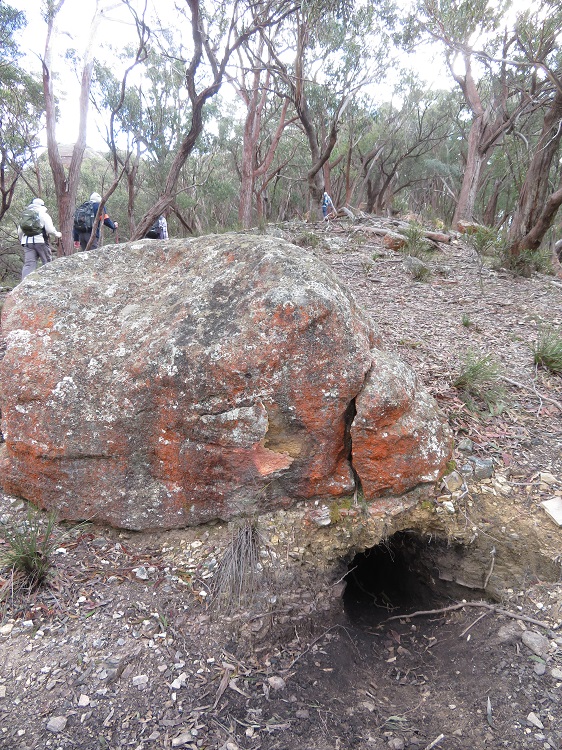
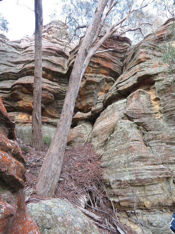
All this changes once you reach the first saddle of the ridgeline. Gorgeous sandstone rock formations are dotted around you and you can either walk around them or scramble straight over the top. It all adds variety to the path. Massive wombat holes are easily spotted as they use the boulders as protection or scaffolding for their dens.
Strolling along, the path varies between well-worn animal thoroughfares to blazing your own way. Up you climb again, around rocks, along cliffs and stepping over fallen trees and branches. This route would be tricky for people who are not steady on their feet or those not in love with heights.
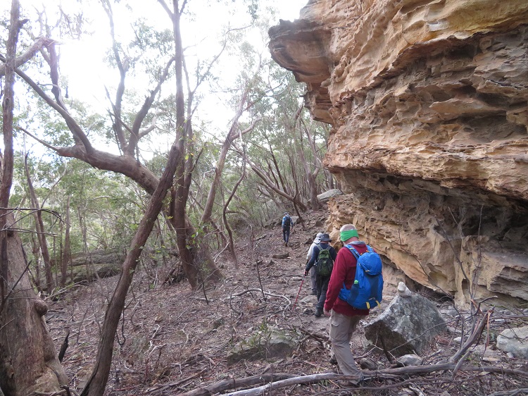
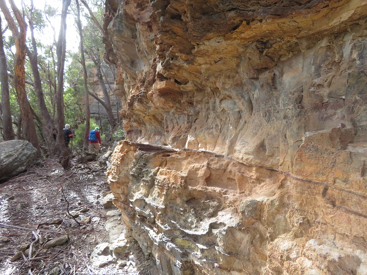

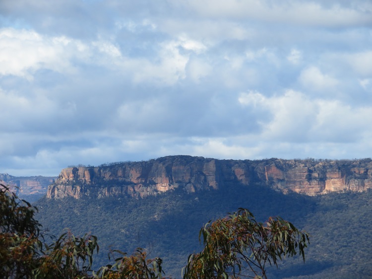
Soon you reach the main rocky outcrop which forms the body of Blackman’s Crown. Use this to guide you on your direct out and back path. As always, the sandstone cliffs are colourful and sculptural. If you look closely, you can clearly see the rock layers made up of different colours and gravel content. I am no geologist, but it is interesting to wonder about the formation of these cliffs. Caves and other areas out of direct sunlight feature a vast range of mosses and ferns determinedly clinging on.


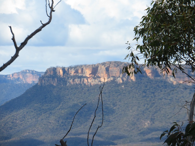
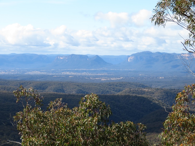
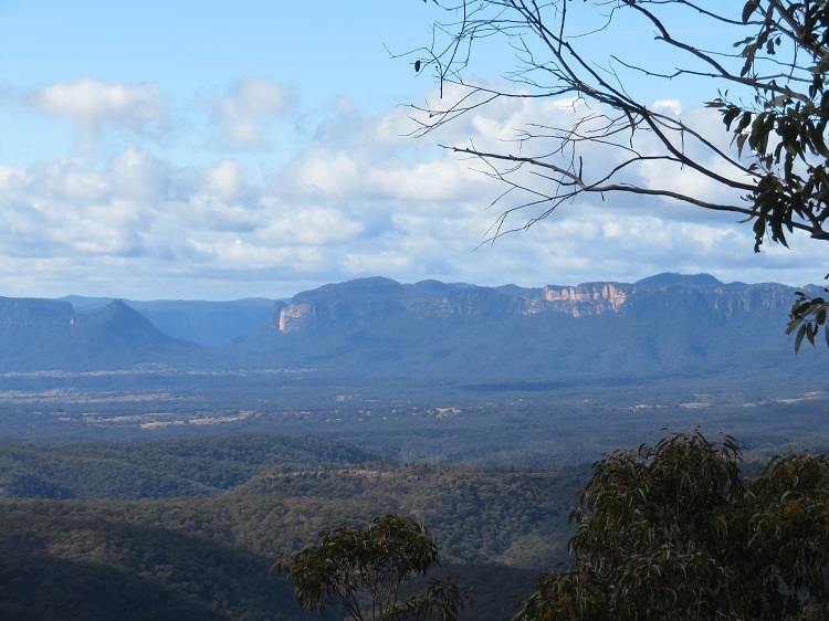
Phew! You have arrived at the top and surprisingly, the terrain opens out into lightly timbered woodland. Near the edge of the plateau fallen trees make perfect seats for you to sit and enjoy your lunch and the stunning views eastwards over the Capertee Valley and its soaring escarpments. It would be so easy to sit for hours just watching the cloud patterns and the changing colours of the cliffs as the light brightens and dims in response to the shuffling clouds.


What a perfect way to spend a mid-Winter’s day?
What does your perfect Winter’s day look like?
The Basics
What: This walk would be a good introduction to the region which could be extended with visits to the Gardens of Stone National Park and the Wollemi National Park.
Where: Capertee is approximately 183km north-west of Sydney.

When: I would not walk in this area in the height of Summer. Too darn hot and more snakes than water.
Why: This walk is all about the views from the top.
How: You will need your own car to get to Capertee. A public bus does pass through Capertee on a daily basis, but it does not pick-up or drop-off near this walk.
Who: This is not an accessible path for those with mobility challenges. You don’t need to be super-fit to enjoy it, just be prepared for the steep terrain going up and, of course, down. Take your time, catch your breath and enjoy the views that surround you.
Related Posts: For more views, beautiful cliffs and shale-oil connections, check out my post about the Pipeline Track.
Related Blogs: Peter is also a keen bushwalker and enjoyed the views from Blackman’s Crown.
Read About It: For a bit of a bush adventure, track down a copy of a book called The Lady Bushranger by Pat Studdy-Clift. The story follows the life and times of a local lady, Jessie Hickman, who careered around the countryside stealing cattle and hiding them in the hidden nooks and crannies of the Capertee Valley.

#bushwalk #travelinspo #shortwalks #CaperteeValley #Capertee #australianflora #canyons #greatoutdoors #heartstarter #daywalks #sandstone #caperteevalley #mininghistory #shaleoil

Ooh, I love it up the top, Mel… but getting back down again might be more tricky?
LikeLiked by 1 person
No worries, I will help you down. 🙂
LikeLiked by 1 person
Well, it certainly looks steep … wow, those sandstone rocks are huge! The hike looks very similar to some we have done here in SA – thanks for taking me along.
LikeLiked by 1 person
There are so many landscape similarities between RSA and Aus. Just a vastly different accent! 😉
LikeLiked by 1 person
Well that is certainly a wonderful view from the top, thank you once again for taking me with you, I’d never cope with those boulders.
LikeLiked by 1 person
Don’t worry, I’d help you around and over them. I would love to see what magic you could work with your camera on this scenery. For some reason, I just can’t seem to capture the true colours of what I see. Maybe I need to go back and read the camera manual again!
LikeLike
I refuse to answer your question because it is the middle of summer here – haha. I will say that it looks very beautiful. What a worthwhile reward after a long hike.
In other news, I’m sure you heard that the US finally removed that onerous test-to-enter rule a few weeks ago. Does this light a fire under your Mississippi River plans?
LikeLiked by 1 person
I am keen and sewing the seed with the Other Half. Maybe 2024??
LikeLiked by 1 person
We, too, are starting to look into international travel. So exciting!
LikeLiked by 1 person
It is exciting, although I do feel a bit rusty. It has been 5 years since I jetted o/s. I wonder if I will still remember how to do it? 😉
LikeLiked by 1 person
We just got back from a Colorado road trip and we even felt rusty on that!
LikeLiked by 1 person
:-)! I suspect we will both find our travel mojo without too much trouble!
LikeLiked by 1 person
What a great find, love the rocks on the way up and what a great view from the top. Maggie
LikeLiked by 1 person
…and it seems to have rained every day since then! Glad we squeezed this walk in on a gorgeous Winter’s day.
LikeLike