
Have you ever had the experience where an activity or destination has been sitting way at the back of your mind and then BANG, it becomes front, centre and doable? That was me and the Larapinta Trail.
The Larapinta Trail has a somewhat fearsome reputation as a challenging, remote and incredibly beautiful walk, and I found out it was all of those things in spades. Before I launch into sharing the day-to-day highlights, here is a little background on this uniquely Australian stroll.
History of the Trail
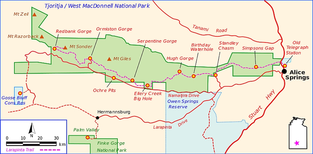
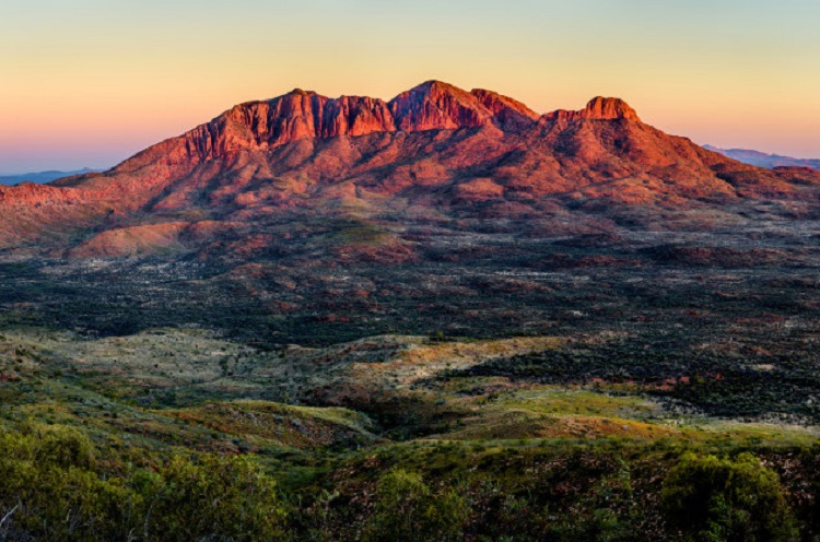
The idea for the Larapinta Trail was first developed in 1989 by the Northern Territory (NT) government. Original plans for the Larapinta Trail extended from the Old Telegraph Station just outside Alice Springs to the highest peak in the NT, Mt Zeil. However due to the remoteness and the rugged terrain spanning between Mt Sonder and Mt Zeil, it was decided that the trail should end at the equally spectacular Mt Sonder, one of the territory’s highest mountains. After many years of development and community consultation, the Larapinta Trail in its current form was finally completed in 2002. Source.
Where is It?
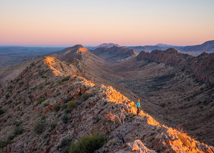
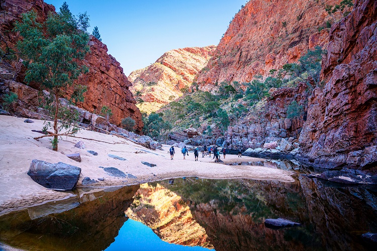
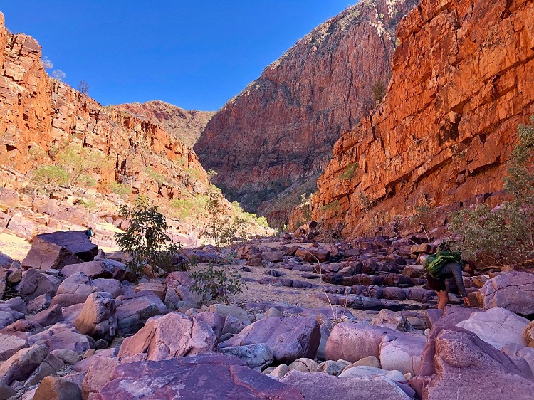
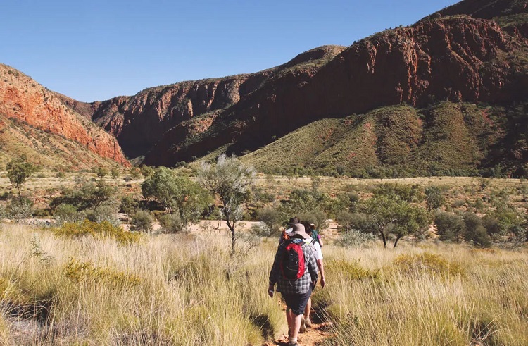
The trail starts (or finishes) approximately 3km from Alice Springs in the NT. It stretches 223km westwards meandering up, down and through the Tjoritja/West MacDonnell Ranges National Park – the land of the Arrernte people – to Mt Sonder.
You have the option to walk it in either an easterly or westerly direction, with West-to-East being the most popular option as it means that if you are ahead of schedule you can simply walk back into Alice Springs from the Old Telegraph Station, rather than getting stuck at Mt Sonder waiting for a lift.
Stages
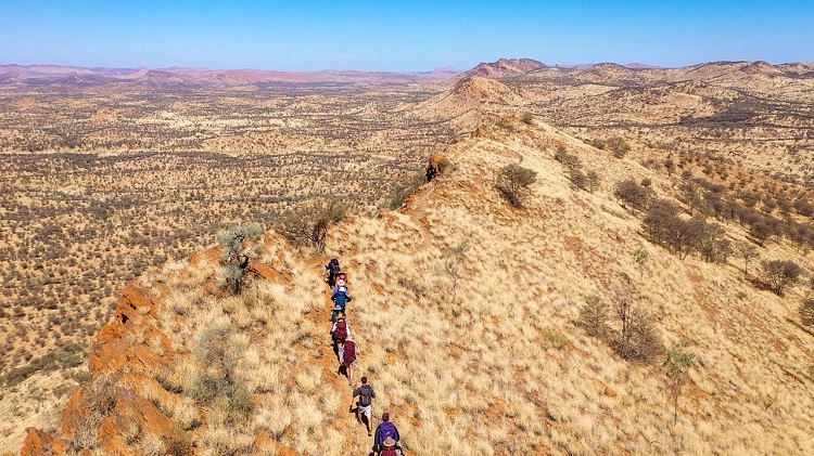
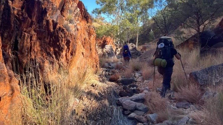
The trail is divided into 20 sections of varying length and terrain. Many people cover the distance in 13-14 days by joining a couple ‘easier’ sections together. This is quite doable if you are fit and prepared to carry additional water.
NT Parks has allocated a rating to each stage, ranging from:
1 – Easy (disabled access)
2 – Easy
3 – Moderate
4 – Moderate to Difficult
5 – Difficult
Believe me, when they say ‘Difficult’, they are NOT kidding and even the ‘Moderate-Difficult’ rating is challenging.
How to Walk the Larapinta Trail?
You can walk the trail as an Independent walker (commonly referred to as an Indie) or join one of the many companies who offer supported walks ranging from 6-9 days of highlights or the complete end-to-end over 14 days/13 nights. While there are pros and cons for both modes, I am very pleased I chose to walk the full distance with World Expeditions on a supported tour with two excellent guides. Yes, I could have completed it independently, but my enjoyment levels would have been severely impacted and my knees would not have been happy! 😊
Infrastructure
At the end/start of all sections is a water tank and composting toilet (except the Old Telegraph Station which has much fancier facilities). Some sections also have a 3-sided shelter where independent hikers can sleep on an elevated platform if need be. There are also cabinets to safely store food away from animals and solar-powered USB charging points.

Signage and waymarking is generally excellent with large information boards at most trailheads and blue triangles indicating the direction at regular intervals along the path. In some sections this has been impacted by bushfire, but I understand both NT Parks and the Friends of the Larapinta make an effort to keep all signage in good condition. The risks are too great if people lose the trail.
When to Go?
DO NOT contemplate walking this trail in Summer. It truly is a life and death situation. I walked in the middle of Winter and even then the temperatures hit 25°C on a couple of days. On one long day I consumed 5litres of water as I walked. Dehydration and heat stroke are real dangers out on the trail and last year a couple of young men died (in Autumn) from not carrying enough water and being prepared.
Who Should Walk?
This trail is recommended for experienced walkers only with a solid level of fitness and good preparation/organisation. I saw walkers of all ages from late teenagers to mid-70 year olds. There are no limitations as long as you know what you are getting yourself into and are prepared.
It was pleasing to see many young women in small groups or walking solo. It is a very safe and social trail, and I could tell that the Indies were forming strong friendships as they walked.
Getting There/Getting Away
The Larapinta Trail is supported by a number of companies who will drop you off to start walking or pick you up at the end. They will also deliver resupply boxes along the trail so you do not have to carry 14 days or so of food etc. No doubt it is like a mini-Christmas as the Indies open their resupply packages.
What Does It Cost?
Walking fees and camping fees are payable to NT Parks as well as the cost of transport, resupply and incidentals etc.
Resources
If this trail has peeked you interest, then have a look at the following links:
- Facebook: Has a very popular Larapinta Trail group and they are a great source of information, support and gorgeous photos. HERE
- NT Parks: You can order maps through their website and make all your bookings. You must pay for a Parks permit, plus trail and camping fees. Bookings usually open 12 months in advance. HERE
- Alice Springs Tourism: Can help you with background on what else there is to see and do in the region and where to stay. HERE
- NT Tourism: Gives you the lay of the land for the whole Territory. HERE
- World Expeditions: If you are not keen to carry a 15-18kg pack, then check out what this company has to offer. HERE
- Book: For a ye olde, hard copy book option, grab a copy of the Larapinta Trail guidebook by John and Marcia Chapman.
And stay tuned for my daily posts over the next few months….
(And in case the credits don’t show in the banner photo, I thank treklarapinta.com.au for capturing to true essence of the Larapinta Trail)
#travelinspo #LarapintaTrail #multidayhikes #adventurebeforedementia #longdistancewalks #australianbush #AliceSprings #WorldExpeditions #bushwalks #greatoutdoors #crosscountry #exploreonfoot #NorthernTerritory #CentralAustralia #discovernorthernterritory #WestMacDonnellRanges #OutbackAustralia #hikingadventures #epicadventures

see any of those huge frogs from South America?
LikeLiked by 1 person
Are you talking about cane toads? If yes, they have not made it to this part of Australia, thankfully. It is too hot and dry for them, but they are definitely in the northern parts of the Northern Territory. The really damage the ecosystems.
LikeLike
And they can kill your pets! A cane toad killed our dog in Panama. Beware!
LikeLiked by 1 person
Yes, they are an environmental disaster and so hard to eradicate. (P.S. I tried to comment on your last post and it wouldn’t let me. I will keep reading and trying. Mel)
LikeLike
So beautiful, just breathtaking
LikeLiked by 1 person
Definitely!
LikeLike
Oh Mel, you and your challenging hikes 👀. I think I need a glass of wine to get through the stages with you (and to enjoy the stunning views)!
LikeLiked by 2 people
Make that a bottle of wine!! 🙂 More fun and games to come!!
LikeLiked by 2 people
It truly is stunning scenery around there. We visited Simpson’s Gap, Standley Chasm where we first saw rock wallabies, and Palm Valley where I drove the landcruiser along a dry river bed, so exciting. I can’t imagine how you trekked through that landscape.
LikeLiked by 1 person
Isn’t it just amazing? The colours just blew my little mind! Yes, it was tough going, but so worth it.
LikeLiked by 1 person
Gorgeous scenery. If we were in Australia longer (much, much longer), this would rank highly. Looking forward to your day-by-days.
LikeLiked by 1 person
You may never want to leave! 🙂
LikeLiked by 1 person
Wow, this looks rugged and beautiful, and very different from most of your through hikes. I’m looking forward to hearing more about your trip!
LikeLiked by 1 person
Watch this space! Every day delivered the most wonderful views and a few physical challenges! 🙂
LikeLiked by 1 person
Look forward to reading of your adventure. When we visited Alice Springs a few years back we did about an hour on a section of this trail at Standley Chasm which wetted our appetite but we’ve never been back since to the centre. Cheers
LikeLiked by 1 person
There is soooooooo much beauty out there, isn’t there? It’s harsh, but stunning. Have a good day, mel
LikeLike
You have been a busy bee 😉 There is something about the outback that gets under your skin. What an amazing place and the images are wonderful, Mel. Well done you for taking the plunge and doing it as I did research on it and I concluded it wasn’t going to be an easy walk.
LikeLiked by 1 person
Thanks, Suzanne. I can’t lay claim to any of these gorgeous images, but I have plenty to share in the next posts. You are right, it is an amazing place.
LikeLike
Sounds amazing Mel, can’t wait to read more!!
LikeLiked by 1 person
It’s coming! Hold that thought..
LikeLike
I walked various very short sections of the trail last year .. not sure I could manage the whole walk but really looking forward to your entries after this great introduction.
LikeLiked by 1 person
It was a tough one, but such a special experience.
LikeLiked by 1 person
Sorry for late response but I have just read your part 1 detail and loved it.
LikeLiked by 1 person
Thanks so much for your feedback. A very different holiday to your most recent one.
LikeLiked by 1 person
In terms of holiday I really do mix it up .. just love travelling and being out there – location secondary – Bali to Paris ot Belfast to Pyongyang and of course Aus .. all good.
LikeLiked by 1 person
I’m with you! There is nothing like being out and about!
LikeLiked by 1 person
Wow! What a trail – the colours and views are just incredible
LikeLiked by 1 person
Yep, it was a cracker!
LikeLike
I’m going to read these posts, I promise, as crucial research for next year, But…later…. for obvious reasons.
I read in a post recently that something like 70% of E2E walkers are women and over 50% of solo trekkers are women. Sounds like a good one to do as a solo woman.
LikeLiked by 1 person
No pressure. I can shortly bore you silly in person! And yes, the majority of walkers we saw were women – either solo or in small groups. Girl Power!
LikeLiked by 1 person
What a long trek! I’m impressed that there are stations with some shelter and such to stay at along the way and to pace yourself. Best of luck!
LikeLiked by 1 person
In the scheme of things, it is one of my shorter walks, but no less challenging. It was a wonderful experience.
LikeLiked by 1 person
Looks beautiful. I’ll have to check it out if I ever make it back to Australia
LikeLiked by 1 person
This trail would give you an amazing insight into Aus.
LikeLike
Wow this is so interesting. I’m looking forward to reading all tour posts from this trail. Definitely not for the faint hearted.
LikeLiked by 1 person
It was an amazing adventure!
LikeLiked by 1 person
Oooohhh! I love a good multiday trek. Thanks so much for writing about this. Good on you for tackling such a big objective. I’ve skimmed your daily treks and they are all so stunning and beautiful. Congratulations on a successful trip!
Alisen
LikeLiked by 1 person
It was an absolute cracker!
LikeLiked by 1 person
I bet! That’s a long time to be out on the trail, especially in the heat. I was just hiking in Nevada, USA and I just about died from the heat, and that was in November. As a cold-blooded Canadian, I find the heat very sapping. I was way more tired than I thought I should have been.
Do you get used to the heat, or does it still affect you?
LikeLiked by 1 person
No, I never get used to the heat and I prefer Winter to Summer in Australia. I am more than happy to get up very early and start walking to avoid the worst of the heat. Today it was up to 34°C and it’s not even Summer yet. 😳
LikeLiked by 1 person